
Old Man of the Mountains before it collapsed
Making Beauty:
Proposals for Public Landscapes
. . . including plans for creating or improving four natural parks in southern New Hampshire. These pieces were written by Robert Gillmore, the landscape designer who created the Evergreen garden and who is now president of the Evergreen Foundation. Many of these proposals reflect Gillmore’s passion for naturalistic landscaping and for woodland gardens especially. Others focus on the built environment.
- Why We Should Rebuild the Old Man of the Mountains
- Why Mount Kearsarge Needs Just One Tower
- Bedford’s Pulpit Gorge Could Be the Preeminent Natural Scenic Area in South-Central New Hampshire
- Make the Londonderry Town Forest a Forest Park
- New Boston’s Piscataquog Peninsula: A Splendid Site Could Be a Splendid Park
- Manchester’s Merrimack River Islands Would Make a Magnificent Natural Park
- Manchester’s Central Park: The Valley Cemetery Isn’t Just an Old Graveyard—It Could Be One of America’s Greatest Urban Parks
- Geographic Synecdoche: The Awful Power of the Center Over the Image of a Place
- The Dorset Solution, Or How to Camouflage Bad Buildings with Good Ones
- ‘I Can’t Wait Until That Door Comes Off That Building’
- How Do We Know Whose Name Should Go on the Main Street Bridge?
- Be a Road Steward
1.
Why We Should Rebuild the Old Man of the Mountains*
When a couple marries in the Russian Orthodox Church, they take part in a wonderful rite. As they walk, arm in arm, around the altar, they are followed by two close friends or relatives who hold golden crowns over their heads. The crowns symbolize the proposition that God has made men and women the kings and queens of Creation.
Like many religious ideas, this one is a moving metaphor for a secular notion: that human beings have a special dispensation. Unlike almost any other creature, we don’t need to accept the natural world as we find it. We can transform it. We have the power to make it better.
We know, for example, that nature almost never makes beautiful gardens—even natural gardens—all by itself. Central Park in New York City, for instance, was not preserved by Frederick Law Olmsted and Calvert Vaux; it was mostly made, lake by lake, tree by tree.
![]()
In naturalistic landscaping, nature does most of the rowing—it grows the plants—but the designer steers. When nature can’t be improved, nature is left alone. But where it can be enhanced, it’s not left alone. It’s enhanced. For the greatest good of landscape gardening is not to preserve nature. It’s to make beauty; and in naturalistic landscaping, enhancing nature is a means to the end of beauty.
We should remember that when we decide whether or not to rebuild the Great Stone face, also known as the Old Man of the Mountains.
Before the profile fell into Franconia Notch in 2003 it was an extraordinary natural sculpture. The writer Stephen Winship of Concord, New Hampshire, got it exactly right, I think, when he called it “the finest human face carved in stone by nature known to man.”
The profile was not just a symbol of New Hampshire or important only to New Hampshire citizens. It was part of the natural patrimony of the world. And its shape, though fine, was only part of its allure. The rest was location: in the very heart of the most impressive natural scenery in eastern North America.
![]()
The peaks and passes (known as notches) of the White Mountains are the most stunning mountain-and-valley scenery east of the Rocky Mountains. If they were not already a national forest, they would long ago have been made a national park, and the park would be acclaimed as the most spectacular national park in the East.
Franconia Notch is arguably the most impressive place in the White Mountains, and the Profile Lake section—in the narrow height of the pass, walled in by Cannon Mountain on one side and the ragged Eagle Cliffs of Mount Lafayette on the other—is the grandest part of the notch.
When you drive through Franconia Notch from the south, your views get better and better as you climb higher and higher, until they climax beside Profile Lake. This point—the very heart of the most sublime scenery in the East—was marked by the Great Stone Face (as Nathaniel Hawthorne called it), which came into view exactly here.
![]()
The profile was thus perfectly situated: not only at the height of the notch, but at the very best possible position on Cannon Mountain: It was a splendid finial on the end of a long spur of the mountain, and just above the long apron of trees sloping to Profile Lake. The profile and the lake worked together: the lake brought your eye down, the profile drew it up, and together they accentuated the sweeping west wall of the notch.
Like other well-placed sculpture, the profile also marked the site as special and made one pause to savor it.
New Hampshire without the profile is like Yosemite Valley without Half Dome, France without Mont St. Michel, Rio de Janiero without the Corcovado and its huge statue of Christ.
Obviously we can’t rebuild the profile exactly as it was—the granite would be too heavy; the new profile would be as unstable as the old—but we can build it to look exactly as it was. Sculptors, set designers, and other artists could use aluminum, fiberglass, and other strong but lightweight materials to create an exact replica of the profile and affix it to Cannon Mountain.
![]()
Some say a replica would look “tacky.” But that’s not true. Some people think vinyl siding looks tacky because—up close—it doesn’t look like wooden clapboards; it looks like a poor plastic imitation of clapboards. It’s bad trompe l’oeil, a trick of the eye that, alas, does not trick.
A replica of the profile would be different. Like the original, it would be high up on Cannon Mountain, at least 1,000 feet from the floor of the notch, which is the closest point from which most people would view it. From that distance, the replica, properly sculpted and painted, would easily look enough like the original to pass for it; it would be successful trompe l’oeil.
Some people object that a replica wouldn’t be “honest” or “authentic” or “genuine.” That’s true but irrelevant. As Edith Wharton and Ogden Codman nicely put it (in The Decoration of Houses), ornamental design is an aesthetic, not an ethical art. What matters in ornamental design is not what we actually see, but what we think we see. If a replica of the profile looks like the profile—if the replica is good trompe l’oeil—that’s all we need; the design works.
While honesty is not required in ornamental design, it is required in park interpretation—which is why honesty and accuracy are best served, not by failing to rebuild the Great Stone Face, but by erecting signs on Profile Lake explaining that the new profile is an exact rendering of the original, which fell in May, 2003.
![]()
Skeptics also claim that it would be “disrespectful” to build a replica. But the opposite is true. If imitation is the sincerest form of flattery, replication of the profile would show how very much we treasured it.
Besides, the Old Man, despite its name, and despite what some people seem to think, really isn’t a person and, therefore, deserves no more “respect” than any other inanimate object.
Still others object that we shouldn’t rebuild the profile because “God” or “nature” took it down. That’s wrong too. God or nature are responsible for lots of nasty things, but no one objects if we repair our houses and gardens after windstorms or fight tooth decay by brushing our teeth and visiting the dentist. For that matter, no one complained that the turnbuckles and epoxy once used to try to keep the profile from collapsing were an unwarranted interference with nature. We routinely repair or replicate beloved architecture and other man-made objects. Why not great natural ones? Do we not value them at least as much?
Some people also assert that the profile’s demise teaches us about the natural processes of decay, that nature (or God) both giveth and taketh away.
That’s also true, and I am willing to fully acknowledge every single lesson about the natural processes of decay that we have learned from the fall of the Old Man. But you can affirm all of these phenomena and come not one whit closer to proving that the profile should not be rebuilt.
![]()
Some people argue that a small replica of the profile, perhaps near Profile Lake, is an “adequate” memorial. But we don’t need a memorial of the profile. We need the profile, just as it was: full size, in its proper place, high above the lake.
Yet another objection made to rebuilding is cost. But a replica (like the original) would be relatively small—about 50 feet high. It would cost (I would guess) about $100,000 to make. And because it would be lightweight, the holes to fasten it securely to the mountain would probably cost another $500,000 to make. That’s about $600,000 in all, or about 50 cents for every man, woman, and child in New Hampshire. The profile was so deeply loved that that amount could be raised quickly and easily by private individuals, businesses, and other organizations.
New Hampshire has been burdened of late with many debilitating deceptions, all of which begin with the words, “We can’t” or “We can’t afford.” In politics as in landscape design, laissez faire does not become us.
Every one of us is aware of the importance of the Great Stone Face. We all know that the world is a lesser place without it.
Its absence, however, is a loss we simply do not need to bear. We and millions of other people enjoyed it for decades, and there is no good reason why millions more can’t enjoy it for decades to come.
In sum, the argument for rebuilding the profile is overwhelming, while the argument against it is weak.
Rebuilding will make us feel doubly good: We will savor the special joy that comes from shaping the world, intelligently and creatively, to our delight, and we will again enjoy Franconia Notch with the jewel in its crown.
* The original version of this article appeared in the August 18, 2003, edition of the Manchester Union Leader.
2.
Why Mount Kearsarge Needs Just One Tower*
The argument about communication towers on prominent peaks such as Mount Kearsarge seems to polarize into two camps.
One group concedes that the towers are eyesores but insist that they’re a necessary evil, like telephone poles: one of the prices we pay for modern convenience: as Oliver Wendell Holmes said about taxes, the price we pay for civilization.
The other group replies that the price is simply too high: mountaintops are too precious to be defaced.
Happily, there may be a way out of this impasse. Consider two points:
- Towers are not inherently unattractive. On the contrary, towers are among the most beloved pieces of the world’s built landscape. Think of the Eiffel Tower, the Washington Monument, or a Roman column. Or think of skyscrapers or Gothic cathedrals, which are among the most exhilarating buildings on the planet; they’re essentially towers with broad bases.
- Towers (or towerlike structures) on mountaintops aren’t inherently unattractive either. On the contrary, mountains are often ideal places for towers because mountains are natural pedestals. The famous statue of Christ on the Corcovado in Rio de Janeiro, for instance, is an inspired union of a soaring natural rock base and a monumental sculpture. The War Memorial on Mount Greylock, in Massachusetts, for another example, is enhanced by its setting on a lofty, ledgy, evergreen-festooned summit.
More modest examples are fire towers. Few people who dislike the communication tower on Kearsarge object to the fire tower beside it, or to other fire towers on other summits across New Hampshire (about which, see below).
A final example: The view of Cannon Mountain from the top of Mount Pemigewasset in Franconia Notch is actually enhanced, not diminished, by the tower on Cannon. From Mount Pemigewasset (and other places in the notch) the Cannon tower appears to rest on the tip of an elegant natural point on the very top of the mountain, so the tower is a wonderful finial, or finishing element. The tower and its base is a happy marriage of the human-made and the natural.
![]()
The main reason, I think, that we don’t object to fire towers is that they’re within the classical pale. Yes, they’re made out of pieces of metal bolted together—just like communication towers—but they’re usually shaped like obelisks, with four flat sides tapering inward as they rise and a hip roof made of four triangular planes. They’re distant country cousins of the Washington Monument.
Unfortunately, communication towers are different. They’re designed in the aesthetic vacuum created by two awful modern ideas: that form should be merely functional and that certain objects don’t need to be beautiful, because they’re merely utilitarian.
The remedy for ugly towers, however, isn’t to banish all towers. It’s to remember John Ruskin’s dictum that objects must be useful and beautiful. It’s to make communication towers at least as attractive as fire towers.
This may be challenging at first, not because making beauty is hard (although it is) but because, to the builders of communication towers, the very idea will be new. But once it’s part of the specifications, it could become routine. In time, stock solutions and off-the-shelf designs could become common. Copying good examples of towers (several of which are listed above) is not only permissible, it’s desirable. (As any good designer will tell you, if you can’t improve upon the best, thank God you can copy it.)
![]()
Even the most beautiful tower, however, will not be right for every mountain. Summits that already have one structure—a fire tower, for example—should almost certainly not have another. The general design rule of thumb is: one space, one focal point. When applied to mountains the rule becomes: one summit, one tower.
Mount Kearsarge would look fine if the only thing on it were a fire tower. Like the tower on Cannon Mountain, a lone Kearsarge fire tower would be a neat little accent near the very top of the peak.
The mountain would look good because the fire tower, especially when seen from below, is not unattractive; the prospect would be unified because the tower would be the only decorative element on the summit; and the composition would be symmetrical because the lone tower would be (and, more important, would appear to be) in the approximate center of the main peak’s two shoulders.
![]()
The present summit, however, is a visual mess. Because the two visible communication towers (one small, one very large) don’t look like the fire tower, or even like each other, the summit isn’t unified. It’s a mishmash.
The present towers are also asymmetrical. To be symmetrical, the two communication towers would have to be the same height, and the fire tower would have to be between, and roughly equidistant from them. (In fact, the tall communication tower is on one end of the row of towers and the fire tower is at the other end.)
But even if they were symmetrical, three towers would look worse than one because the two communication towers would compete for attention with the fire tower, thereby dissipating the power if the single focal point.
A work of art, Aristotle said, is something to which nothing needs to be added and from which nothing needs to be taken away. Like an overgrown garden, Kearsarge would go from a mess to a (modest) work of landscape art if two of its towers were weeded out and the functions of all the towers were performed by one attractive structure.
* The original version of this article appeared in the October 11, 1998, Concord (New Hampshire) Monitor.
3.
Bedford’s Pulpit Gorge Could Be the Preeminent Natural Scenic Area in South-Central New Hampshire
I first heard about Pulpit Rock (so-called) in 1972, when I moved to Manchester. But I never went to see it until 20 years later.
Why did I wait so long?
Because I had no idea the place was so stunning. Nothing I had heard or read about it even began to describe the brook, the gorge, the waterfalls, or any of the other marvels of the site. Frankly I had imagined only a big boulder in the woods.
One reason for my ignorance about the site is its name: “Pulpit Rock” is tragically inverse hype, the equivalent of calling Niagara Falls “Niagara Water.” Pulpit Gorge is more like it. You could also call it “Pulpit Ravine” or even “Pulpit Cliff.” Any of the three would be an improvement.
![]()
Like too many other beautiful natural areas, Pulpit Rock suffers from woefully inadequate PR. Eileen Oktavec and I have been writing the Great Walks guides, which cover the best day hikes in the national parks, since 1989. We begin each project by reading other writing about the sites and occasionally interviewing people about them. Almost without fail people will say simply that a place is “beautiful,” “pretty,” or other all-but-useless adjective. They cannot or will not tell you, either orally or in writing, what a place actually looks like. (Nineteenth-century guidebooks, for all their florid prose, were usually much better at simple description.)
In any event, I wasn’t surprised that, despite hearing about Pulpit Rock for years, I still had no idea how remarkable it is.
Pulpit Gorge—if I may take the liberty of calling it that—is simply exquisite. Without exaggeration it’s the most impressive natural rock-and-water composition in the Merrimack Valley I know of.
![]()
The path to Pulpit Gorge begins at a parking area on New Boston Road, just east of the Bedford-New Boston line. A nearly level half-mile walk through the woods brings you to Pulpit Brook, just downstream from a pretty three-foot-high cascade that pours over a ledge into a wide pool.
In another tenth of a mile, you reach the head of Pulpit Gorge. Here, suddenly, a very ordinary second-growth woodland becomes an extraordinary place. You’re now atop a massive ledge, in the middle of which is an awesome U-shaped chasm whose vertical rock walls plunge as much as 40 feet to a shallow pool at the bottom.
At the head of the gorge, a slender branch of Pulpit Brook descends a long, ledgy channel, then slides 8 or 9 feet down a shallow stone groove at the lip of the gorge, then turns into a frayed white rope of water as it falls 15 feet to splatter on rocks on the floor of the ravine.
You can walk around the nearly level top of the gorge and see the chasm from several vantage points. (Be careful: There’s no fence.)
![]()
For even better views you can follow the orange-blazed trail to the bottom of the ravine. There you’ll see the walls of the gorge, which were carved thousands of years ago by the rushing water of melting glaciers and by tons of rock debris carried along by the turbulent runoff.
The rock debris hollowed out the ravine and scoured the walls of the upper gorge into smooth concave scallops that are as much as 12 feet wide and sweep diagonally from the bottom of the chasm to the top.
The upper gorge is about 40 feet wide and 50 feet long; its floor is a shallow sheet of water. High above the pool, the roots of hemlocks and other evergreens cling tightly to crevices in the rock.
Below the upper gorge Pulpit Brook curves between trees and along another tiny channel, then pours 10 feet over more ledge before splashing into a 20-foot-wide pool. The shallow pool floods the bottom of the lower gorge, which is another semicircular ravine with smooth, mossy rock walls as high as 30 feet.
Below the lower gorge, the landscape changes again—from the sublime to the picturesque, from gorge to glen. The smooth vertical walls of bedrock are replaced by rough, sloping banks; instead of quiet inky sheets of water you now see thick, white columns surging over handsome, ragged, mossy rock and falling into deep, wide pools bound by lovely curving moss-covered ledges.
This part of the brook—which runs for several hundred feet—is one of those rare and wonderful places where nature is as beautiful as a garden, where everything is just right, where, as Aristotle said of a work of art, nothing needs to be added, and nothing needs to be taken away.
![]()
While Pulpit Gorge is stunning, however, the Pulpit Rock Conservation Area (as it’s called) is far from perfect. At least six things could be done to help this special place reach its potential.
First: Change the name. Frederick Law Olmsted, the rightly reputed father of American landscape architecture, knew that beautiful landscape features could be made even more appealing if they were given names suited to their beauty. That’s why Central Park, in Manhattan, and Prospect Park, in Brooklyn, both co-designed by Olmsted, are replete with evocative, romantic names like “the Loch,” “the Meer,” and “the Belvedere.”
Olmsted would have grieved if he knew that Pulpit Gorge was called Pulpit Rock. Especially in New England, a rock—a mere rock—is almost nothing. (“The Pulpit,” another moniker, is no better—it’s even vaguer than “rock.”)
Second: The gorge is a startlingly simple composition of smooth rock and water. Any tree limbs, rubbish, or other debris in that spare natural room easily becomes an unwanted focal point that transforms a beautiful space into an ugly one. The gorge is a tough master: It’s got to be kept perfectly clean.
Third: The waterfall at the head of the ravine should be the jewel in the crown—or, better, the diamond in the ring—of Pulpit Gorge. The cataract should be as big as possible: an imposing column of white water framed by the dark rock walls on each side of it, crashing so loudly on the rock below that ordinary conversation is difficult, smashing with such force that it sends clouds of mist rising up the canyon walls.
The waterfall is small because Pulpit Brook plays a dirty trick on Pulpit Gorge: Before falling into the gorge, the brook divides into two streams, and, worse, the larger one runs parallel to the ravine, not into it, before it rejoins the smaller branch below the lower gorge. In other words, at the very point where you want the entire brook to stay together and fall into the gorge, it splits apart and most of it goes elsewhere.
The solution, of course, is to channel the brook so all of it falls into the gorge. That could be done with a combination of large pipes, carefully hidden from view, and dikes, artfully shaped so they look natural, not artificial.
Fourth: Cataracts, cascades, and other falling water is best seen downstream, because that’s the only place from which you can see the entire face of a fall.
Ideally, the path from the parking lot would take you not directly to the gorge but to the bottom of the cascades on Pulpit Brook. From there the path would follow the brook upstream, offering continuing views of falling water, and the route would climax in the upper gorge, where you’d look up at a big, crashing waterfall at the head of the ravine.
The present approach, unfortunately, does everything wrong:
- It follows the brook downstream, not upstream.
- It reaches the gorge first, not last, so the rest of the brook is anticlimactic.
- The path first takes you to the top, not the bottom, of the gorge; so, while your first view of the gorge is a wonderful surprise—that, in fact, is the best thing about the present approach—the rest of the route does everything backwards.
As Olmsted himself knew, good landscaping includes good path-making, which enhances the natural beauty of a site by properly sequencing and framing views. The present approach squanders the site’s potential.
Fifth: The trail to the gorge is marred by old tires that support wooden bridges over seasonal streams. Old tires belong in transfer stations, not where anyone can easily see them, and especially not in a place whose raison d’etre is beauty.
The bridges could be supported more attractively by stones.
Or, better still, large, flat rocks could be installed for stream crossings. Unlike wooden bridges, rocks never rot, so they never need replacing. Also, unlike bridges, rocks can look natural. And—mirabile dictu!—they’re cheaper than bridges.
Sixth: Admission to the gorge is free of charge, but it still exacts a price: To get there, you have to walk more than half a mile through mostly unremarkable woods.
There are two solutions to that problem:
- Shorten the approach by building the access road much closer to the gorge. Or:
- Make the woods beautiful by transforming them into a woodland garden: that is, by planting drifts of shade-tolerant evergreen plants—broad-leafed shrubs such as rhododendrons and mountain laurel; ground covers such as ivy, pachysandra, and vinca—along the path to the gorge. (Most of the existing plants are native herbaceous perennials and ground covers of very limited ornamental value.)
![]()
My first suggestion (renaming the gorge) is virtually cost free (and surely the easiest to implement); the second requires only volunteer labor; the third, fourth, and fifth projects are more costly, and the sixth is a budget-buster. Together they would require some serious fundraising and the cooperation of many community groups.
All these projects, however, don’t have to be done right away, and doing just some of them —indeed doing any one of them—would improve the site markedly. The idea is to do as much as possible as soon as possible.
And think of what the community would get for its effort: Bedford would enjoy pride of place as the home of the preeminent natural scenic area in south-central New Hampshire, a signature landmark that would bring even greater luster to the town.
* A version of this essay first appeared in the March 15 and March 21, 2001, editions of the Bedford (New Hampshire) Bulletin.
4.
Make the Londonderry Town Forest a Forest Park*
The town of Londonderry, New Hampshire, is deciding how it should best use the small town forest near its town center. When she was serving on the Londonderry Heritage Commission, Ann Chiampa asked me if I would look at the site and make some suggestions.
I walked through the forest and the land around it last summer, and I came to two major conclusions:
First: The forest’s use should relate to its location.
The forest is fortuitously located next to an attractive, spacious, still-almost-rural town center comprised mainly of public, or quasi public infrastructure—schools; churches; a cluster of historic structures, including an 18th-century Cape; and a prominent common with war memorials. The town center has almost no residential and commercial development, and it’s partly surrounded by open fields and large, lovely apple orchards. The town forest abuts both the common and the orchards, and is easily and frequently accessed by roads linking all three areas.
This context suggests that the forest should not be used for forestry but instead should be groomed into a woodland park that would complement the common and the orchards by being a naturalistic extension of both. Like the common, the orchards and other open areas nearby, a groomed forest would be a fine venue for walking, cross-country skiing, snowshoeing, and other, similar outdoor recreation. It would also be a welcome shady respite on hot summer days.
(In contrast, forests dedicated to long-term timber production are not and cannot be as attractive as woodland parks. They’re necessarily scruffy woodlands, of many different sizes of trees, which are managed not for beauty but for timber. Forestry should be practiced in sites more isolated and less well located than this one.)
Second: The town forest’s design should be determined by its existing aesthetic assets.
No one will mistake the town forest for the White Mountains: It has no waterfalls, rushing streams, or any other major water features; no ledges, cliffs, or other ornamental rock; no mountain vistas; and no remarkable shrubs or ground covers—in short, almost no existing natural gifts that could be major features of a naturalistic garden.
But the forest does have some grand old trees—mainly oaks and white pines. Unlike smaller trees, these are big enough to have (or begin to have) interesting textured bark, sculptural root flare, and simply the presence that comes from nothing more than size and old age. These big trees are the major ornamental, or aesthetic, assets of the town forest.
![]()
The first step in transforming the town forest into a forest park, or woodland garden, is to enhance, or make the most of, its big trees. You do that by removing anything that obscures, interferes with, or distracts attention from them, or that detracts from the beauty of their surround. This means grooming, or what I call gardening by subtraction. This includes:
- Cleaning up, or removing all dead trees and branches, both standing and fallen, as well as any litter or other debris, from the site.
- Weeding, or removing unwanted live plants (usually brush and small trees) that detract from the beauty of the site. In the town forest, that includes getting rid of the poison ivy, oriental bittersweet and other vines, plus scrawny raspberries and blackberries struggling in the dim light; all of them diminish the aesthetic impact of the big trees.
- Pruning, or removing unwanted parts of live plants, such as cutting off a branch to make a tree more attractive or to open up a path.
Gardening by subtraction should be done not only around the large trees, but also around two other, minor ornamental assets of the forest: the small grove of hemlock trees near its eastern edge and the little pond near Pillsbury Road.
The other major asset of the town forest is its roads. These wide, smooth, often-level (or nearly level) pathways have just enough curve to be unmonotonous; they traverse much of the site; they lead to a view of the orchards; and they could easily be made handicapped-accessible. They’re literally thousands of dollars worth of trails that—because they already exist—do not need to be created.
The forest’s initial gardening by subtraction should be done along these trails, where it will be most readily seen and appreciated. Ideally this grooming should be done as far into the woods as it will be seen—usually at least 50 feet, sometimes as much as 100, depending on the contour of the land. If you can’t do this all at once, begin along the road edge and work outward. If you can’t do all the trails at once, pick the most popular routes—or parts of them—and begin there.
Gardening by subtraction makes a woodland more attractive—cleaner, open, more parklike—all by itself, and without buying a single plant. It requires only labor.
After the subtraction is finished, you can make the forest even more scenic by adding clusters of low-maintenance, shade-tolerant evergreen shrubs such as rhododendrons and mountain laurel.
All this work could be performed and funded at least partly by volunteers—garden clubs, service organizations, etc.—and perhaps by a new organization (“Friends of the Town Forest Park”?) dedicated to the creation and maintenance of what could become an extraordinary public landscape.
* Earlier versions of this article appeared in the Derry (New Hampshire) News on January 15, 2015, and in the Londonderry (New Hampshire) Times.
5.
New Boston’s Piscataquog Peninsula: A Splendid Site Could Be A Splendid Park*
The peninsula at the confluence of the Middle and South branches of the Piscataquog River in New Boston, New Hampshire, could become a splendid naturalistic park.
The site—near the intersection of Gregg Mill Road and Route 13, in Lang Station State Forest—is already extraordinary, so it could be transformed into an exceptional woodland park with a wonderfully small amount of time and money.
Consider the assets of the site:
First, there’s the long peninsula, or point, on the opposite side of Gregg Mill Road from the former railroad station, the simple but handsome fieldstone structure after which the Lang Station State Forest is named.
The peninsula begins on Gregg Mill Road and extends for more than 300 feet before ending at a low, narrow point where the Middle Branch, on the left bank of the peninsula, flows into the South Branch, on its right bank.
The peninsula provides many close views of both branches of the river. The vistas are pleasing because both the South and Middle branches are briskly flowing and picturesque.
The eastern half of the peninsula—the section beyond the arching footbridge over the Middle Branch—is narrow—only about 60 feet wide—so it provides simultaneous views of both branches of the river. It’s one of only a few easily accessible places in New Hampshire where you can stand in the middle of two rivers—as if you were on a little island—and be almost surrounded by moving water.
At both the end of the peninsula, and along its south bank, you can also see several hundred feet up and down the South Branch—a large expanse of flowing water.
Even more river views are provided by the graceful low-arched bridge over the Middle Branch. When you stand in the middle of the bridge you can see far upstream, plus downstream to the confluence of the South and Middle branches, and across the South Branch itself.
![]()
The peninsula, however, is more than a supremely well-located linear observation platform. It’s also a very attractive, almost gardenlike space in its own right.
It’s dominated by large, handsome white pines, as well as by several equally big hemlocks, maples, and other deciduous specimens, many with trunks between two and three feet thick at the base. Like the trunks of all giant trees, these giants are natural sculpture, the organizing elements (the so-called “bones”) of a garden, and the vertical dimension of garden rooms.
Other, much lower ornamental plants already on the site are low-bush blueberries, valuable for their fruits and scarlet cold-weather foliage; the ephemeral Canadian mayflower (Maianthemum canadense); patches of wintergreen (Gaultheria procumbens), an evergreen ground cover with red berries and wine-red winter foliage; and lesser amounts of partridgeberry (Mitchella repens), another evergreen ground cover with bright red berries, as well as tiny, neatly paired leaves.
The eastern section of the peninsula is especially attractive. Just beyond the footbridge there’s an almost solid grove of hemlocks, whose massed evergreen foliage provides impressive year-round color and interest.
Just beyond the sweep of hemlocks, at the narrow end of the peninsula, is the loveliest part of the site. Here, fortuitously, nature has already created a nearly gardenlike vignette: a clean, spare, open space dominated by a few huge evergreen trees, including a massive white pine near the tip of the peninsula with large roots that sprawl across the floor of the site. The pines are so big that—despite heavy foot traffic—they produce enough foliage to keep the floor of the space almost permanently carpeted with a handsome layer of brown needles.
The end of the peninsula is a natural belvedere: a beautiful spot fit for gazing at beautiful stretches of river in almost every direction.
Transforming this beautiful site into a woodland garden requires two steps.
![]()
Step One: Gardening by Subtraction
The site is already so attractive that, to transform it into a naturalistic park, or woodland garden, it needs mainly grooming, a process I call “gardening by subtraction,” and which I divide into three parts: cleaning up, weeding, and pruning. Gardening by subtraction is relatively economical: It requires the purchase of no plants and can be done entirely by volunteers.
Cleaning up is the removal of all standing and fallen dead trees and branches, as well as any human-made debris (litter, etc.) on the site. Cleaning up the peninsula would be relatively easy because there’s almost no debris and very few large fallen trees. Most of the dead wood is fallen branches and small standing trees that have died from lack of light under the canopy of big trees.
Weeding is the removal of unwelcome live plants—primarily small, spindly, deciduous trees and scruffy woody shrubs—that contribute only clutter to the scene and detract from attractive features on a site—in this case, the river, the big trees, the hemlock grove, the blueberry bushes, and the ground covers described above—and would also detract from any evergreen shrubs and ground covers that might be added (see below).
The few tiny, skinny deciduous trees cluttering up the hemlock grove, for example, should be removed to strengthen the impact of the hemlocks, which is produced by the unity of the mass.
Most of the weeding is needed in the woods in the western end of the peninsula, next to Gregg Mill Road. I would remove every tree less than six inches in diameter. This would release the remaining larger species, allowing them to grow faster, and would create a clean, open, parklike woods; it would also make spaces to add mountain laurel (see below) and allow more sunlight into the woods for the laurel to blossom well.
(In a mature woodland, it is almost always the trunk of a deciduous tree, not the crown, that gives the tree ornamental value, because the crown is usually lost in the canopy. It is the trunk that makes the tree attractive, and the bigger the trunk, the more attractive and more impressive the tree. In woodland gardens, the rule of thumb is: The bigger the tree, the more valuable the tree.)
The eastern end of the peninsula needs very little weeding, because it contains very few small trees or woody shrubs. What weeding that could be done here, however, would also enhance the site by opening up more views of the river.
No weeding is recommended on the river banks; shrubby plants here provide some erosion control and, in any case, are not easily seen from the woods above them.
Pruning, of course, is the removal of branches that are dead, that block a pathway, or that make a tree badly shaped. The peninsula actually needs very little pruning—mainly cutting unsightly dead branches off larger trees.
Together, clean-up, weeding, and pruning beautify a woodland by simplifying and clarifying it. By removing unattractive elements, it enhances the remaining attractive elements by emphasizing them and removing anything that detracts from them. Gardening by subtraction makes a woodland more open, more attractive, more parklike, more pleasing all by itself.
Michelangelo famously argued that a sculpture already exists in the stone; the sculptor simply reveals the sculpture by removing the stone around it. Similarly, much of a woodland garden already exists in the landscape; a gardener simply reveals it by removing unwanted plants within it.
Aristotle defined a work of art as something to which nothing needs to be added and from which nothing needs to be taken away. In a woodland garden, gardening by subtraction executes the second half of Aristotle’s dictum.
![]()
Step Two: Adding Evergreen Plants
The first half of Aristotle’s dictum is executed by adding appropriate plants to the site. In a woodland garden, you don’t need to add trees—they’re already there. (The wonderful thing about woodland gardening is that the largest, most expensive plants in the garden—the big trees that are unavailable in any nursery at any price—are already there, already planted, already growing nicely.) Shrubs, ground covers, and other small plants, however, are welcome additions of foliage and blossom color in the lower levels of the woodland.
On the narrow eastern end of the peninsula, most of the (small amount of) open space is a footway. There is virtually no room for shrubs and, happily, no ornamental need for them. But there is some room for small plants away from foot traffic and near the bases of trees.
I suggest planting evergreen ground covers there. Evergreens provide year-round interest and—perhaps more important—they have a higher survival rate than herbaceous plants, because only evergreen plants announce their presence year round, so conscientious people can stay off their beds.
Vinca minor (known as myrtle or periwinkle) is a good ground cover because it’s tough and attractive and produces profuse lavender flowers. It’s also economical: it spreads quickly, so a few plants can carpet a wide area; and it’s popular enough to be available from large wholesalers for only about 25 cents a seedling. Also, growth of the existing ground covers might be encouraged by adding composted manure or other organic fertilizer.
![]()
The woods in the western end of the peninsula (along Gregg Mill Road) are not nearly as attractive as those in the eastern end. Gardening by subtraction would improve them greatly (see above), but what would make them beautiful is about 50 mountain laurel (Kalmia latifolia).
A native shrub that grows elsewhere along the Piscataquog, mountain laurel bears handsome evergreen foliage and exquisite white flowers in June. Also, unlike rhododendrons, it’s seldom eaten by deer. For best display, I would layer the shrub along the paths, taller plants in back. When in bloom, “The Laurel Woods” (as I would christen them) would be a beautiful, celebrated sight.
As money became available, the laurel could be underplanted with evergreen ground covers and other small plants.
![]()
Besides plants, I would also add a few benches and at least one picnic table to the site. In this woodsy, naturalistic site, handsome, all-wood pieces are best; nothing should be more formal than a Lutyens bench. For durability, I would choose heavy, well-made pieces.
Ideally, they would be placed where they would offer the best views of the river and where they’d be out of the way of foot traffic. The narrow eastern end of the peninsula has room only for one or two benches at most. Probably the only commodious space for a picnic table is near the footbridge.
The furniture would rank with the mountain laurel as the priciest items in the project. Like the plants, however, they could be added over time, as fund-raising allowed. And, as with plants, landscape professionals would be happy to arrange for wholesale purchases.
Fortunately, furniture and plants are only part of the project. The rest of it—gardening by subtraction—involves virtually no out-of-pocket costs at all. It requires only volunteers, a few tools, and a dump truck to remove the debris.
![]()
When completed, the Piscataquog River Park would easily be the most beautiful public garden in New Boston and one of the community’s most celebrated assets.
It would be a worthy and quite doable project for one or more civic organizations—the garden club, conservation commission, school groups, and Scouts all come to mind—and for any individuals interested in landscape gardening. Funds might also be raised from businesses, foundations, and other groups. I would be delighted to help in any way I can.
* The original version of this article appeared in the May, 2003, edition of The New Boston Bulletin.
![]()
Preserving Natural Processes Is Not the Only Good
In the June, 2003, edition of The New Boston Bulletin, Dorothea Pelham opposed Robert Gillmore’s proposal for a Piscataquog River Park. This is a slightly revised version of Gillmore’s reply to her in the July, 2003, edition of the Bulletin:
Mrs. Pelham’s letter earns an A for knowledge but, I’m afraid, an F for judgment.
Yes, the woodland park I proposed for the peninsula at the confluence of the Middle and South branches of the Piscataquog River (May 2003) would interfere (slightly) with natural tree succession and plant and animal habitat. But any human use of wooded land has similar effects.
Clear-cutting forests to make room for new houses, schools, or other buildings interferes with tree succession and habitat rather severely. Does Mrs. Pelham object to that? What about cutting trees for lumber? What about hunting or fishing? Or simply walking through the woods—with or without a dog? Every one of those actions interferes with natural processes, at least a little. The essential question is: How and where does Mrs. Pelham draw her lines? How, for that matter, does anyone?
![]()
Most of the eastern United States is naturally a forest. Buildings, roads, gardens, and campgrounds exist here only because trees have been felled—and natural processes affected—to make room for them. In fact, our entire civilization is an abridgement of natural processes.
We tolerate this abridgement for two reasons:
- We believe that preserving natural processes is not the only good; other human wants supercede.
- Development affects only the minor share of our land. The majority remains wild or only lightly used (for outdoor recreation or occasional timber cutting, for example). After the claims of civilization, there’s enough land left over where natural processes are largely (though almost never entirely) left alone.
The natural processes at the confluence of the proposed woodland park are already compromised by people and dogs moving through the site. I propose to compromise them only slightly more by modest grooming of the woods and by adding mountain laurel, a native shrub.
The peninsula is less than an acre. That means the park would slightly interfere with natural processes in less than one per cent of one per cent of the land in New Boston. The other 99.999 per cent would be unaffected. Virtually all the town’s ungroomed, lightly used woodlands—thousands of acres in all—would be unaffected by the proposed park.
Naturalistic landscaping, including woodland gardening, interferes with natural processes less than virtually any other landscaping style. It is, for example, the very opposite of typical lawn-and-flower-bed gardening, which wipes out the entire forest.
It’s too bad—and too ironic—that this minimally intrusive landscaping style is foolishly attacked, while much more destructive styles are not.
6.
Manchester’s Merrimack River Islands Would Make a Magnificent Natural Park*
Two of the most delightful features of Yosemite National Park, in California, are the Happy Isles. The twin islets, in the middle of the Merced River, offer exciting views of the wild, noisy stream as it surges out of Merced Canyon into the head of Yosemite Valley.
Manchester could create its own, urban version of the Happy Isles in the chain of forested islands in the Merrimack River just below the Amoskeag dam.
Like the Happy Isles, the Merrimack River islands are fortuitously located. Views from the islands would include lake-size expanses of (sometimes churning) water, huge thickets of white water pouring over the dam, and the mile-long wall of 19th-century brick mill buildings that once housed the world’s largest textile manufacturing enterprise.
Like the Happy Isles, the river islands are close enough to the riverbank and to each other so they could be easily linked by footbridges.
![]()
I’d build arch bridges. They’re practical—high enough to be out of reach of spring high water. They’d be handsome civic architecture. And they’d symbolize the former Notre Dame Bridge and other tall bridges that once spanned the Merrimack.
The islands would need only two bridges. One would run from the west side of the river in front of the Amoskeag Fishways Visitor Center to the northwestern shore of the northernmost island, only about 150 feet away.
The second bridge would link the northernmost island with the even larger island only about 100 feet south of it. The impressive stone walls on each side of the channel could be incorporated into bridge abutments.
(The two southern islands are too low to be developed.)
![]()
I would also build paths along the shore of the islands, as close as possible to the river, and more trails to other viewpoints and interesting natural features such as ledges and big trees. Like the bridges, the paths would permit uninterrupted views of the river and its surroundings from every direction.
I would also groom the islands’ woods, removing brush and small trees. That would open up views and create a handsome, open forest park of stately pines and hardwoods.
I would also install attractive, durable benches and picnic tables.
The islands would be a natural extension of the Amoskeag Fishways Visitor Center. Staff members could lead tours of the site and explain the area’s fascinating natural and human history—which could also be described by permanent signs and exhibits.
In sum, the islands could become—hands down—not only the most exciting park in Manchester but one of the most dazzling urban parks in the country: one-and-a-half naturalistic acres for walking, picnicking, learning, and river watching. Not least because people like to walk to islands, the park would be very popular.
![]()
Most of the world’s great cities have incorporated their rivers into great landscapes. Think of the Esplanade in Boston, the Brooklyn Heights Promenade in New York, river walkways in San Antonio, Tacoma, Paris, Rome, Zurich and dozens of other places that all prove this truth: A river is often a city’s largest, most compelling natural feature; it should be made as visible and accessible as possible.
Rivers are the (linear) lakes of cities. The long stretches of water are wonderful to look at. They provide strips of nature in the middle of dense development. They both offset and highlight the built landscape around them.
Manchester is starting to appreciate, open up, and enjoy its river. A River Islands Park would advance that movement dramatically. It would be the diamond in the ring of Manchester’s Merrimack Riverscape.
![]()
The islands are owned by Eversource, the electric utility. The city could acquire the two larger ones (where the park would be built) with a mix of private fundraising and public money, including state and federal land-acquisition funds. The islands are unsuited for almost any commercial use, so their fair-market value, and therefore their acquisition cost, should be low.
The only other major expense would be the bridges. Grooming, path-making, and other landscaping would be relatively minor costs and, given the excitement that this project would generate, donations of money and services would be generous.
Early versions of the article appeared in the April 30, 2001, Manchester Union Leader and the February 7-13, 2002, edition of the Hippo, Manchester’s weekly tabloid.
7.
Manchester’s Central Park: The Valley Cemetery Isn’t Just an Old Graveyard—It Could Be One of America’s Greatest Urban Parks*
The Valley Street Cemetery is one of Manchester’s best-kept secrets, mainly because, like a Florentine palace, it hides its treasures inside a plain exterior.
If you walk or drive around it—it’s bordered by Pine, Auburn, Willow, and Valley Streets—it doesn’t look amazing. Almost all you can see is an old iron fence, some of it battered and rusted, and a few trees and gravestones beyond. You have no idea that the cemetery contains some of the most beautiful historic architecture in New Hampshire and one of the most impressive urban park landscapes in the Northeast.
The architecture includes a charming Gothic Revival stone chapel built in 1932 and a half-dozen stone tombs—in Gothic, Greek, and Egyptian revival styles—that inter the remains of Manchester’s most prosperous 19th century families.
![]()
Even more impressive than the buildings, however, is the dramatic ravine—the great valley—after which the cemetery is named.
The valley is enormous: more than 800 feet long, more than 30 feet deep, 40 to 80 feet wide at the bottom, 100 to 200 feet wide at the top.
The steep slopes of the valley run 30 to 40 feet from top to bottom—so high that they block out all signs of the city and most of the sounds too.
When you walk along the bottom of the valley, you see only the valley. You’re in the middle of a city of more than 100,000 people, and less than a block from the civic center, yet the city could be miles away.
This dramatic topography helps create a romantic island of idealized nature in a sea of civilization. This kind of landscaping—sometimes merely picturesque, but sometimes so dramatic as to be sublime—was a signature of great 19th-century urban park-making.
![]()
The great valley is why the cemetery ranks with three masterpieces of the era: Central Park, in Manhattan, and Prospect Park, in Brooklyn, both co-designed by the great landscape architect Frederick Law Olmsted; and the famed Mount Auburn Cemetery, in Watertown, Massachusetts, built ten years before the Valley Cemetery and which was at least an inspiration, if not a model for the latter.
Like other early “garden cemeteries,” Mount Auburn and the Valley were not just places to bury the dead; they were also “pleasure grounds” for the living.
To appreciate the Valley, compare—or, rather, contrast—it to Mount Auburn. The latter is all curves. Its endlessly and irregularly undulating topography is ideal for the naturalistic landscape that Olmsted considered the antidote to the city’s grid of buildings and traffic. Like Olmsted’s original Central Park, Mount Auburn is big enough and curvy enough to screen out the city entirely.
When Central Park first opened, the buildings around it were only three or four stories high—low enough to be hidden by trees along the edges of the park. But the invention of the elevator soon made tall buildings practicable, and—since a landscape includes everything you can see from within it—multi-story buildings are now a part of Central Park; the unity of its naturalism is, from many viewpoints, broken by views of the city.
Unlike Mount Auburn, much of the Valley Cemetery is flat, most of its roads are humdrum straight lines and right angles, and, mainly because the cemetery is relatively small, much of it is exposed to the buildings and traffic around it. (The iron fence screens nothing.)
![]()
The glorious exception to that rule, of course, is the great valley. The valley is the cemetery’s principal strength, and it more than compensates for all its weaknesses.
To appreciate the valley still more, consider Central Park again. When Olmsted (and his partner Calvert Vaux) designed the park, they were required to build roads across it so traffic could cross from one side of the city to the other. To preserve the naturalistic character of the park, the roads and their traffic needed to be screened—just like the buildings around the park. The partners’ clever solution was not just to screen the roads with berms and plants but also to depress them—to sink them so low that they were out of sight. To this day, people in Central Park rarely see or hear the thousands of cars speeding over its roads. O & V’s plans to screen out the buildings broke down, but the transverse road scheme has never failed.
The great valley is just like Olmsted and Vaux’s transverse roads, but in reverse. The roads hide development by hiding it below grade, the valley hides development by hiding it above grade. Both screen out the sights and sounds of the surrounding city from the park. Both work mainly because of topography.
![]()
The valley, however, is much more than an effective barrier. It’s also an exciting landform in its own right—especially because it’s such a surprise in the middle of a comparatively flat city center. The valley is so valuable that it ranks with such renowned urban park features as the Great Meadow in Prospect Park and the Belvidere in Central Park.
Like good naturalistic landscaping, the valley isn’t straight. It honors the old aphorism that “there are no straight lines in nature.” It curves diagonally, northeast to southwest, through almost the entire cemetery. Because of its curves, you can never see all of it at once—its steep slopes hide one end of the valley from the other. The curve of the valley, however, pulls you forward—you want to keep walking to find out what’s around the bend—and views of the ravine unfold only gradually, as you stroll through it.
Designers call this effect “progressive realization,” because views are seen, or “realized,” successively, or “progressively.” Instead of encountering just one vista, you encounter many. That’s good because, the more views you see in a landscape, the richer is your experience of it; and because a landscape is judged by that experience, the richer the landscape is felt to be.
![]()
The bottom of the valley is a long, nearly flat sweep of turf. Along the edge of the grass, on each side of the valley, at precisely the point where the slopes of the valley rise from the valley floor, is an undulating asphalt path.
The path, still in good condition, is perfectly situated. By running along the very edge of the valley floor, it’s as close to the slope as it can be without actually climbing it.
The closer the path to the slope, the greater the effect of progressive realization, because the closer the path to the slope, the more of the valley that’s blocked by the slope, the more slowly each view of the valley is revealed, the longer it takes to see the entire ravine, and the grander the great valley is made to appear.
Also, the closer the path to the slope, the longer the path’s total length. And the longer the path, the longer it takes to walk the valley, and the larger the valley feels. (The paradoxical rule of design: the longer the path, the larger the garden.)
Another nice effect: By keeping to the edge of the slope, the path stays off the grass, leaving the entire valley bottom a large, unbroken belt of turf—in fact, the largest possible sweep of grass in the valley floor.
![]()
The valley is dominated by two buildings at the top of its eastern slope. One is the Smyth mausoleum, a beautiful recreation of a Greek temple, with four Ionic pillars supporting a pediment. The temple rests on a massive stone base—broader than the tomb itself—that reaches almost 20 feet down the slope. To the left of the tomb is the rear of the Gothic Revival chapel with its comforting thick buttressed walls.
The Smyth building is especially welcome, not only because of its stylish classical motifs, but also because it’s wonderfully sited. Perched dramatically on the crest of the slope, it lords over the entire valley and draws our gaze up to it. It thereby emphasizes, simultaneously, both the height of the bluff and, in contrast, the depth of the big valley.
![]()
The slopes of the valley are not only dramatic. They’re also a splendid planting opportunity. Plant them with sweeps of blooming shrubs, and the massive displays of color would make the valley nothing less than one of the greatest naturalistic gardens in America.
The valley’s original planting scheme was typical of the mid-19th century: a large greensward dotted with larger specimen trees and a few (mainly deciduous) shrubs. This planting style is perhaps most closely associated with Alexander Jackson Downing, almost certainly the most celebrated landscape designer of the ante-bellum era, and author of the classic work, The Theory and Practice of Landscape Gardening, which was first published in 1841, the same year (not entirely coincidentally) that the Valley Cemetery opened. (If Downing had not died prematurely in a steamboat explosion, he, not Olmsted, might have been chosen to design Central Park, and he, not Olmsted, might be considered the father of American landscape architecture.)
A Downing grass-and-trees planting scheme, of course, is ideal for most public park space because grass is a ground cover that can be walked on—that, after all, is its principal value—and planting mainly trees on the grass ensures that much of the grass remains open for playing, sunbathing, and other park activities.
![]()
Grass, however, is not appropriate for garden slopes because (1) people seldom walk there (except on steps) and (2) they’re hard to mow. The main reason that the flat surfaces in the Valley Street Cemetery are well mowed is because mowing them is relatively easy. The main reason the slopes of the valley are a jungle of unattractive weedy vines and other émigré plants is because mowing them would be labor-intensive, time-consuming, and therefore expensive work.
According to old photographs of the cemetery, even the slopes of the valley were originally planted with grass. Perhaps that made sense in 1841, when labor was cheaper and grass was still cut by hand. But it makes no sense today—especially when there are much better alternatives.
While a slope is a problem when planted with grass, it’s an opportunity when planted with blooming shrubs. Many of America’s great gardens—Winterthur in Delaware, Airlie in North Carolina, Middleton in South Carolina, Calloway in Georgia, to name just a few—are distinguished by large sweeps of evergreen shrubs that create absolutely stunning masses of color when in bloom.
![]()
In many of these gardens the shrubs are planted on slopes. Slopes are excellent platforms to display massed plantings because, on a slope, plants in the front of the mass don’t obscure plants behind them. In fact, the steeper the slope, the more likely it is that every plant on the slope can be seen.
Slopes can also increase the effect of mass plantings by raising them. A shrub mass on level ground can be no higher than the height of the tallest shrub. A shrub mass on a slope, however, can be as high as the slope. And the higher (and wider) the slope, the more stunning the mass can be.
The value of the great valley, of course, is that it has not just one immense slope but two immense facing slopes. Imagine the effect if both slopes were planted with blooming shrubs: As you walked along the bottom of the valley, you would be surrounded—actually embraced—by high, wide, undulating walls of blossoming rhododendrons, azaleas, mountain laurels, andromedas, and hydrangeas. So planted, the valley would be not only the greatest naturalistic garden in New Hampshire, but one of the greatest in America.
Unlike grass, shrub masses are low-maintenance plantings, especially if planted under trees. Unlike grass, they don’t need to be mowed. If they’re well mulched and planted with a generous amendment of peat moss in the back fill, they usually require no watering after the first year. They need little weeding, and not just because of the mulch but also because shade from the trees and the shrubs themselves (especially evergreen trees and shrubs) discourages weeds.
Evergreen shrubs need relatively little fertilizing, because broadleaf evergreens are light feeders and because fallen leaves and needles decay to create mulch, and the mulch breaks down to create fertilizer—just as in a forest.
Massed shrubs need virtually no pruning; on the contrary, the object is to let them grow into each other to create a solid sweep of foliage. When shrubs—especially evergreen shrubs—mass in, they create their own canopy, just like a forest; the ground below the mass is so shady that weeds seldom survive; plus the ground is usually cool and moist—ideal soil conditions.
![]()
A pamphlet published by the Manchester Historical Association reports that the Valley Cemetery was once a “showplace,…a favorite destination for carriage rides, picnics, and Sunday afternoon strolls.”
The cemetery—and especially the valley—could once again be one of Manchester’s most popular parks. Its splendid assets—dramatic land forms, big old trees, a vast carpet of grass, handsome walkways and stone stairs, splendid architecture—are all in place. Its greatest needs are mainly restoration and maintenance.
Surrounded by walls of flowering shrubs, the grass on the valley floor would become one of Manchester’s most popular destinations: a wonderful place for a picnic lunch, for children (and adults!) to play, for reading, sunbathing, etc. It would also be a wonderful venue for special events—art shows, concerts, weddings, parties, etc. The paved path at the edge of the grass is perfect for walkers, joggers, and baby carriages.
![]()
Manchester’s major redevelopment has been gradually moving south. First came the Center of New Hampshire, then the Civic Center, then the baseball stadium and hotels and condominiums along the river. More redevelopment is planned in the “warehouse” and “gaslight” districts nearby. Prime real estate is now almost at the gates of the Valley Cemetery. And, once again, we can look to Central Park for a lesson.
For decades Central Park suffered from inadequate maintenance. Now it’s almost completely restored. The restoration has been financed and directed entirely by a private, non-profit organization, the Central Park Conservancy.
The Conservancy, you may not be surprised to hear, has been funded precisely by those businesses and individuals on the east, west, and south sides of the park—those who have the strongest personal stake in the park’s condition. They include hotels and other hospitality industries, affluent residents who use the park—indeed any property near it.
One law of New York real estate is: All things equal, the closer a building is to Central Park, the more valuable it is. Its corollary is: The better the state of the park—or, more precisely, the better that part of the park that’s nearest to the building—the more valuable the building. Restoration of the park began in its southern sections (and gradually worked north) mainly because, to put it succinctly, the south is where the money is.
The Valley Cemetery is not (or not yet) immediately surrounded by expensive real estate—Valley and Auburn streets are not Fifth Avenue or Central Park South. But that doesn’t matter. The cemetery’s constituency is the entire city, especially downtown. The challenge—the opportunity—is to create a symbiotic relationship between the cemetery and interested people, businesses, and organizations.
The relationship should proceed in tandem: financial (and other) support for the cemetery will make the cemetery more attractive, which, in turn, will encourage more support, which will produce more money, etc., in an endless feedback loop, until, if all goes well, the cemetery becomes the grand and glorious park it was a century ago. The trick is to keep the process moving.
![]()
If the Valley Cemetery is Manchester’s Central Park, then the Friends of the Valley Cemetery is Manchester’s Central Park Conservancy. Formed in 2002, the non-profit Friends have already raised thousands of dollars and have begun restorations, including the iron fence and the elegant Currier Gate on Auburn Street.
Restoration will proceed faster if every friend of the cemetery remembers what makes it extraordinary—and worth restoring—and what makes it just another old graveyard.
What’s not important about the cemetery, for example, is who’s buried there. A few antiquarians may care, but everyone else could care less, because they know it doesn’t matter. What matters about the Smyth mausoleum, for instance, isn’t that Smyth is in it; it’s the building’s beauty and its location at the rim of the valley—those are quite remarkable enough. (And what’s interesting about Smyth is his career, not—of all things!— the location of his corpse.)
Many, if not most of the gravestones in the cemetery are unremarkable; so is most of the flat land around the valley, where most of the gravestones are erected. Like the plain gold ring supporting a diamond, the land around the valley is important only because it’s a setting for the valley. The valley is the diamond; the rest of the cemetery is the plain gold ring. Unfortunately, the more you talk about the ring instead of the diamond, the more people will ask: What’s the big deal about an old cemetery?
The big deal—the huge deal—is the diamond, the great valley, and—if properly planted—the great public park that the valley could become.
* A shorter version of this essay was published on the editorial page of the Manchester Union Leader on January 21, 2002.
8.
Geographic Synecdoche: The Awful Power of the Center Over the Image of a Place
What’s the most beautiful town in New Hampshire?
Some people might say Hopkinton or Gilmanton, with their striking, almost all-white collection of handsome old houses.
Others might say Amherst or Hancock or Francestown, all outdoor museums of fine 17th- and 18th-century architecture.
The answers would differ, but virtually every one would have this in common: The name of the town would refer, not to the whole town, but only to a small part of it: its center. When we think of a town, what happens is a kind of geographic synecdoche in which the part defines the whole.
The phenomenon is universal. Name any of the beautiful cities of the world—Paris, Rio de Janiero, Edinburgh…. Like most big cites, they’re really a collection of mostly ordinary, sometimes ugly, and mostly 20th-century buildings. But we rarely, if ever, think about that. The Paris of our minds is Montmartre and the Champs-Elysees, the much smaller, older Paris along the Seine. Rio is the beaches and the harbor. Edinburgh is (mostly) the castle and the Royal Mile. The rest of the city never enters our minds. Instead, in a benign bit of magical thinking, the part—the beautiful part— becomes the whole.
![]()
This phenomenon gives the part—the center—enormous power over the image of a place.
Usually—in Paris, Rio and Edinburgh surely— the effect is benign: it gives a place an aura far nicer than its (total) reality.
The town of Gilmanton, for instance, is, on the whole, no more beautiful than many other New Hampshire communities. But the splendid group of white buildings at the Four Corners fixes in our minds—and those of its residents—an image of an exceptionally lovely town. Pride of place (and, incidentally, real estate values) swell accordingly.
Sometimes, however, the power of the center is not benign. Greenfield, for example, is, on the whole, an attractive small town with a dozen or more fine colonial houses near, but not at its center. Unfortunately, the very heart of the town—the junction of Routes 31 and 136, where all traffic must pause—is defined by not-so-lovely buildings on or near the intersection. They illustrate the negative power of the center: how, rather like the proverbial mustache on the Mona Lisa, or like a candy wrapper in the middle of an otherwise lovely lawn, just one or a few unexceptional buildings can ruin the center; and a bad center, in turn, can ruin the image of a town.
That’s the bad news—for Greenfield and any place else that has been dealt a bad hand.
The good news is that, like a bad tooth, bad buildings can be refurbished or replaced. (Happily, Greenfield has been gradually doing exactly that.)
More good news is that sometimes—in Dorset, Vermont, for example—bad buildings can be camouflaged. The Dorset Solution, as I call it, is described below.
9.
The Dorset Solution, or How to Camouflage Bad Buildings with Good Ones*
This is a hymn of praise to the parishioners of both historic churches in Goffstown village.
Congratulations, first, to the members of the Congregational church for the superb refurbishing of their building on Main Street.
The big, white Gothic Revival structure is arguably the handsomest, most impressive building in the village. If Goffstown is ever going to have a beautiful town center, it’s because the village has a saving remnant of handsome red-brick and white-painted buildings. This architecture could be the nucleus of a red-brick-and-white-painted streetscape in which the less attractive buildings are visually subsumed by more attractive structures of the same colors and, as a result, the entire village looks better.
One of the best known examples of this phenomenon is the center of Dorset, Vermont. Dorset is well known for its impressive collection of mostly white, mostly 18th-century houses.
But the village actually includes several not-so-attractive buildings, many of which are covered with imitation clapboard siding.
Fortuitously, however, the less-attractive buildings—or at least the less-attractive features of the building—are lost in the crowd, because the lesser buildings are the same color (white) as the good buildings. They’re lost because your eye naturally goes to the best-looking structures. The other buildings almost disappear, because they don’t stand out. On the contrary, they blend in—or at least they blend as much as they possibly can—because they’re the same color as the good buildings. (Think of how people in a marching band look alike because they’re wearing the same uniform.) Because the eye lingers on the attractive buildings, and only glances at the other ones, sometimes it actually “sees” the lesser buildings as good as the good ones!
Thankfully, the members of the Congregational church resisted any temptation they may have had to put vinyl siding on their building,** and any temptation to change its color. Happily, they kept all its beautiful elaborate decorative woodwork alone and repainted it white.
(They even earned bonus points by replacing its slate roof with slate instead of asphalt shingles. While the white-painted facade is critical to the beauty of downtown, the roof is not. The more expensive slate, however, is actually more economical than shingles because it lasts so much longer.)
![]()
Congratulations also go to St. Matthew’s Episcopal Church for its new rectory. The building it replaces was a former single-family home made uninspiring and slightly depressing by its flabby skin of artificial siding.
When the building burned last year, my expectations were modest. The replacement probably wouldn’t be much worse than the original, I thought. Then again, thanks to the miracle of plastic building materials, it has never been earlier to make a building ugly.
I am both delighted and relieved to write that my expectations have been exceeded. Hugely. The new rectory is wonderful—an imitation that flatters the beautiful Country Gothic Revival church beside it. The new building’s soaring gables, board-and-batten siding, and round-topped windows all echo the signature details of the church. I presume—I hope—its color will be white too. [It is!]
![]()
The struggle to transform Goffstown village from an ordinary place to a beautiful one has scarcely advanced in decades. Frustratingly small steps forward have accompanied big steps backward.
Changing the color of what is now Traver’s restaurant from white to yellow was a big step to the rear. Painted white, this awkward building blended nicely into the white streetscape around it. Painted yellow—the only yellow building on Main Street—it draws attention to itself, when attention instead should go to the half-dozen more attractive buildings around it; one of which, of course, is the Congregational Church across the street.***
The refurbished Congregational Church—welcome though it is—is actually not an advance; it merely preserves the unsatisfactory status quo. The new Episcopal rectory, on the other hand, is a big step forward. In this town, where things get better only at glacial speed, that alone is reason to . . . rejoice.
* The original version of this article appeared in the December 32, 2003, edition of The Goffstown News.
** In a later renovation, the church did install vinyl siding; but the damage, happily, was slight, because it put the new imitation clapboards only over its old wooden clapboards. None of the many decorative wooden elements were covered. The result, interestingly, is another demonstration of the Dorset Solution: Because your eye goes to the more numerous, more interesting, more complex decorative features (especially on the front facade) and only glances at the ordinary, simple, repetitive clapboards—and because the white clapboards blend with the rest of the white building—the eye tends, at least at first glance, to see the clapboards as just as real as the rest of the facade.
*** More good news: Travers restaurant is now Sawyer’s and—hallelujah!—it’s white, and, ergo, the church is more prominent than ever!
10.
‘I Can’t Wait Until That Door Comes Off That Building’
Landscape design includes everything that can be seen outdoors, including the outside of buildings. This piece, which first appeared as a letter to the editor in the Goffstown (New Hampshire) News, explains how a single door can visually ruin an entire structure.
The story is told how Frank Lloyd Wright, riding in a car down Main Street in Williamstown, Massachusetts, looked at Griffin Hall, an early-19th-century classical building on the Williams College campus, and grimaced.
“Who put that door on that building?” he demanded in that famously arrogant voice.
Wright was hardly a classical architect, but like most great creative pioneers, he knew his antecedents well. And he knew, perhaps better than his audience, that the door and the building didn’t go together.
![]()
I am reminded of that incident when I drive by the Grasmere Town Hall. Like all classical buildings, the town hall is bilaterally symmetrical. Imagine a vertical line running down the very center of the front facade of the building from the roof to the ground. In a classical structure, every detail on one side of that imaginary line is—or ought to be—a mirror image of everything on the other side.
Break that rule—put, say, just one window out of place—and the facade is ruined. The offending detail(s) are the architectural equivalent of a ketchup stain on a white shirt.
There are two small doors on either side of the main entrance to the town hall. The right-hand door looks authentic—or, at least to this amateur eye, as if it could be authentic. For the town hall to work, the left-hand door must look exactly like the right-hand one. Unfortunately, it doesn’t even come close.
The offender is a classical six-panel (“Christian”) door, except there’s a semicircular fan light where the two small top panels would otherwise be.
![]()
These doors became popular after World War II—about half a century after the town hall was built—and they were almost certainly inspired (if that’s the right word) by Federal doors, whose hallmarks, of course, are lovely semielliptical fan lights. In Federal buildings, however, the fan lights are above the doors, not in them.
The neo-Federal door is triply offensive in the town hall because it’s a design that, happily, is no longer with us; it’s inauthentic by at least 50 years; and—most important—it ruins the symmetry of the building.
![]()
When I mentioned this to Phil D’Avanza, the selectman who’s leading the effort to restore the town hall, he agreed that the door was wrong, but he hastened to inform me that it was installed by an earlier occupant, not by the restoration committee.
When I asked him why the committee hadn’t replaced the door, he said the group had higher priorities: preventing further damage to the building and making it usable again, so more people would “get inside” it and thereby be persuaded to become part of a growing constituency that would support continued restoration of the structure.
In other words, according to Phil, politics must come before beauty—or, rather, politics is a necessary means to beauty.
I’m relieved to discover that Phil’s heart is in the right place, and I am happy to defer to his judgment.
But I am counting the days until that door finally comes off that building.
Postscript: I’m both relieved and delighted to report that the offending door finally did come off the building and was replaced by one that looks just like the door on its right. Happy endings like this are especially sweet because, alas! victories for beauty are all too rare.
11.
How Do We Know Whose Name Should Go on the Main Street Bridge?*
The letter in the November 13 Goffstown News over the signature of Paul Karanikas was an eloquent plea for naming the new Main Street bridge after Richard Backus, the late, legendary Goffstown physician.
I live in the house on Summer Street that Backus built (for $15,000!) in 1941 for his home and office. Many people have told me many things about him, and I don’t dispute Karanikas’ or anyone else’s account of his exceptional skills, extraordinary dedication, and generosity toward poor patients.
But I’ve also heard similar stories about Albert Snay, another longtime Goffstown physician, whom I had the pleasure of knowing for a few years before he died. Like Backus—like many physicians of their era—Snay also made house calls in the middle of winter nights, did much work for free, and saved many lives. How, then, do we know we should name the bridge for Backus instead of Snay?
Another thing: Saving lives is not exceptional for physicians. It’s their job. If we should name bridges after them for simply doing their job, why not also name bridges for policemen, firemen, and emergency medical technicians? They save lives too.
Also: Plumbers and furnace repairmen make house calls on sub-zero nights, and at least a few of them give breaks to the poor. Should we name bridges for them as well?
![]()
I don’t know whom, if anyone, the bridge should be named for. My point is simply this: Like every community, Goffstown has been home to many generous, skillful, and very helpful people who deserve public honors. Only one, however, can be honored by the Main Street bridge. The obvious question is: How do we decide—how do we know—who that one person should be?
I can think of two possible answers to that question:
One is: We should comb through a list of every possible name to make sure we haven’t forgotten anyone, and to make sure we have picked the very best, the one who clearly deserves the honor above all others.
We should, in any event, not pick someone who just died, or for whatever reasons happens to be foremost in our minds at the moment the choice is made, or who happens to be a personal favorite of someone making the choice.
(Several years ago a long-time state representative happened to die just when a new legislative office building was nearing completion. Several people said the building should be named for the newly deceased. Others were shocked by the idea: the member was not outstanding—he was, for example, only the vice chairman of a committee—and there were scores of other lawmakers, past and present, who had accomplished so much more.)
The second possible answer makes the opposite argument: that the selection process does not have to be careful or thorough and that we do not have to choose the most deserving candidate. We might argue, for instance, that Dr. Backus plainly deserves recognition and that it does not hurt Dr. Snay, or anyone else not chosen, not to have a bridge named after him. Giving something to A takes nothing away from B.
But that argument is not quite true. If B deserves the honor more than A but loses it to A, B is affronted. More important, we’re affronted: our sense of fairness is offended. Giving the honor to A does take something away from B; that something is the honor that B deserved more than A.
The selectmen’s decision not to name the bridge after Dr. Backus is sound: Until we’re sure that Backus—and no one else—merits the distinction, the bridge should remain unnamed.
![]()
But not forever. Naming public infrastructure—streets and roads, bridges, reservoirs, cemeteries, playgrounds, schools, libraries, and other buildings (including rooms and other parts of buildings)—is a wonderfully efficient use of public property. A named building, for example, is a major memorial—it’s on the lips, in the eyes, and on the minds of hundreds of people every day—and naming it costs virtually nothing.
Hospitals, colleges, universities, and other private, non-profit organizations are well aware of this economy. That’s why many college buildings and hospital wings are named after the people who gave the money to build them.
And why not? Non-profit organizations need the money, most do good work, anyone who gives them big money is by definition generous, and generosity is at least one virtue that should be honored. In fact, the more money you give, the more generous (by definition) you are, and the greater your honor should be.
Many public schools and libraries are named for their benefactors. Goffstown has several “naming opportunities” (as these things are called by “development,” or fund-raising, professionals)—the high school, the library, the elementary and middle schools all come to mind—and anyone responsible for financing these institutions ought to be giving at least a little thought to the very satisfying work of persuading wealthy, generous, public-spirited people that their names would look very good attached to, say, the library of a new school.
Financial generosity, of course, is not the only virtue that should be recognized. That’s why we should be making lists of people who deserve recognition for any reason. Only then do we have at least a chance of knowing, for sure, which names should go where.
* The original version of this article appeared in the December 4, 2003, edition of The Goffstown News
12.
Be a Road Steward
In Vermont, the first Saturday in May is Green Up Day: Thousands of volunteers pick up tens of thousands of bags of litter from the state’s public roads and streets. When Green Up Day is over, thousands of miles of Vermont roads are litter-free.
But what about the rest of the year? Anyone nasty enough to use a road as a dump is hardly polite enough to wait until just before the next Greenup Day before dumping again. Litterers tend to litter year round. How do we keep our roads clean after Green Up Day—on the other 364 days of the year?
One answer is that more of us can become what many Vermonters already are: road stewards.
Road stewards pick up trash not only on Green Up Day, but all year long. Some police only the road on which they live; others go farther afield. Still others pick up trash (at least occasionally) wherever they see it.
![]()
Two older women I know like to take long walks. Whenever they spy a piece of litter, they put it in the little plastic shopping bag they carry with them. They pride themselves for doing two things at once: getting pleasant exercise while creating a mile or two of litter-free roadsides. And, like many road stewards, they are incredibly efficient: Their walks take more than an hour, but the actual act of picking up litter takes them no more than two or three minutes.
I live on the Hazens Notch Road (Route 58), a lightly traveled dirt road in Montgomery. I rarely get around to take a walk, but every Sunday I have a ritual: As I drive downtown to get the paper, I go slowly enough so that, whenever I see a beer can or other debris, I can easily pull over, get out, pick it up, and throw it in a bag. When I get home, three miles of roadside are free of any trash I can see from my car windows. And that happy result adds no more than 15 minutes to my round trip.
![]()
We could, of course, replace road stewards with state and local highway crews. But to do the same job as my women friends, for example, we would have to pay our road crews not just for the few minutes each week that my friends actually spend picking up litter, but for the seven or more hours they would be simply walking. Unlike road crews, road stewards are hyper-efficient because they multi-task.
They also receive non-monetary compensation. And not just the warm feelings that come from doing good deeds. A piece of litter is what landscape designers like me call a “negative focal point”—it grabs your attention and, all by itself, ruins an entire view. Simply by removing it, you can almost instantly restore the whole scene. Making beauty—or at least ending ugliness—is rarely so easy or so economical. Like removing a piece of lint from a suit, picking up a single beer can isn’t so much a burden as an irresistible opportunity.
![]()
Like many road stewards, I try to pick up trash not just on Sunday mornings but whenever I see it.
Sometimes, however, I’m too busy to stop. I tell myself I’ll stop later.
But later, the trash is gone.
What happened? The wind may have blown it into the woods. An animal (wild or domestic) may have gotten it. Or maybe—as I like to think—one of my neighbors picked it up instead.
And when I think that, I imagine that I am not alone—that at least some of my neighbors are doing exactly what I’m doing. And then I also imagine that my neighbors and I live in—of all things—a state of grace. Not only because we are privileged to live in one of the prettiest places on earth, but also because we are wise enough to know that we are part of an unspoken social compact: Each of us knows that our home is not only our house or our land, but nothing less than all the space we inhabit. We know that our mountain road is as much our home as our living rooms.
We are also wise enough to know that, if we all act as if our common road is also our common home, then it will be light work for all of us to take care of it: that if we all act as if what we imagine is true, then we make it true.
Earlier versions of this essay appeared in the Burlington Free Press, the Barre Times Argus, and the Enosburg County Courier on March 29, 2012.
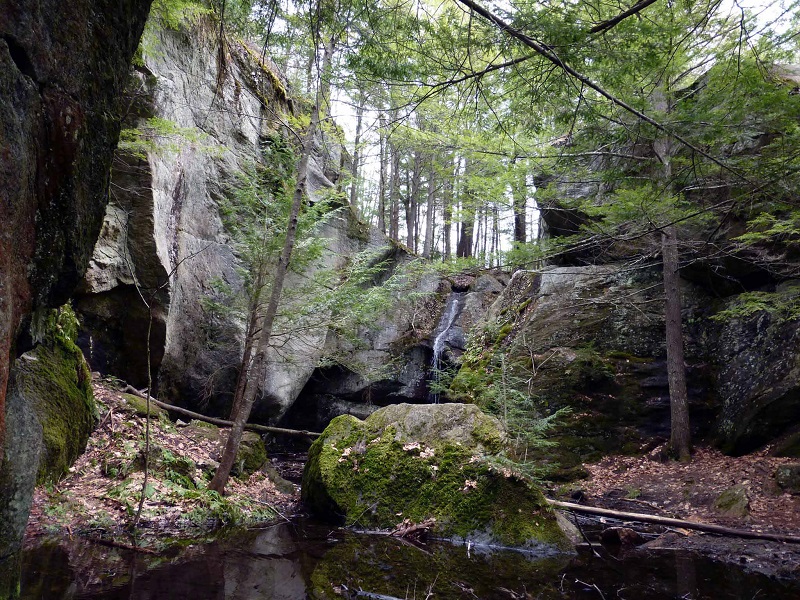
Photo by Piscataquog Land Conservancy